Birmingham weather: One Storm Henk food warnings & four flood alerts remain for Wednesday - listed

and live on Freeview channel 276
Storm Henk wreaked havoc across Birmingham and the wider West Midlands with persistent heavy downpours and wind yesterday (Tuesday, January 2).
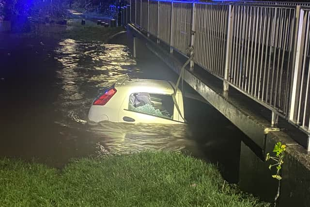
Areas became flooded with one car being pictured as it was submerged in flood water in Hall Green with a young child inside. Police praised a local hero who entered the water to rescue the three year-old and the driver before securing the vehicle to teh bridge to prevent it being washed away in the water.
Advertisement
Hide AdAdvertisement
Hide AdWhile the rain may have relented there remains five flood warnings in place in and around the city and nine flood alerts. Flood Warnings are issued by the Environment Agency when flooding is expected. The government body issues Flood Alerts for areas where some flooding is possible. It has removed one flood alert or warning in the last 24 hours for Illey Brook at Halesowen.
Here is the one remaining Flood Warnings in and around Birmingham for Wednesday (January 3)
- River Blythe at Blyth End - The EA said: “We expect river levels to rise until 06:00 on Wednesday 03 January 2024. We are closely monitoring the situation. Our incident response staff are actively checking river levels and the weather forecast and clearing weed screens. Please move family, pets, possessions, valuables and cars to safety and activate any property flood protection products you may have, such as flood barriers and air brick covers. and take photographs of any flood damage.”
Flood warnings have been removed for the following areas:
- River Blythe at Earlswood - Flood warning area: River Blythe at Earlswood from Valley Road to the Industrial estate. The EA said: “We are closely monitoring the situation. Our incident response staff are actively checking river levels and the weather forecast. Please call 999 if in immediate danger and avoid contact with flood water.”
- River Cole at Coleshill - Flood warning area: River Cole at Coleshill from Cole End to Coleshill Industrial Estate.
- River Tame at Hamstead - Flood warning area: River Tame at Hamstead including Woodend, Greenway, Beauchamp Avenue, The Croftway, Walcot Drive, Hamstead Road, Kirkstone Crescent, Old Walsall Road and Hampstead Industrial Estate areas.
- The Bourn at Bournville - The EA said: “River levels have risen at the Bournville Woodbrook Road river gauge as a result of heavy rainfall. Consequently, flooding of property is possible overnight 03/01/24. Flooding is affecting properties around Bond Street Birmingham. Further rainfall is forecast over the next 12 hours. We expect river levels to remain high. We are closely monitoring the situation. Our incident response staff are actively checking river levels and the weather forecast. Please activate any property flood protection products you may have, such as flood barriers and air brick covers and avoid contact with flood water. Call 999 if in immediate danger. This message will be updated by tomorrow morning 03/01/24, or as the situation changes.”

Here are the four Flood Alerts for in and around Birmingham on Wednesday (January 3)
- Middle Tame - Flood alert area: Low-lying land and roads between Water Orton and Tamworth including the Bourne Brook at Fazeley.
- River Rea - Flood alert area: Low-lying land and roads between Longbridge and Nechells on the River Rea
- River Salwarpe - Flood alert area: River Salwarpe, Elmbridge and Hadley Brooks and their tributaries.
- Upper Tame and Sandwell Valley - Flood alert area: Upper Tame at Sandwell Valley.
Met Office Weather forecast for Birmingham
Today: Somewhat brighter than yesterday with a mixture of cloud and sunny intervals. However there'll also be showers, these heavy at times and possibly merging into bands of rain. Less windy. Maximum temperature 9 °C.
Tonight: Clear spells and a few showers overnight and turning a bit breezier. A colder night with a patchy frost in rural areas. Minimum temperature 2 °C. Thursday: A largely fine day with sunny periods and just the low chance of a shower. Light winds and feeling a little cooler than of late. Maximum temperature 8 °C.
Outlook for Friday to Sunday: A largely dry period with perhaps just an isolated shower or two. Often cloudy but occasional bright or sunny spells. Turning gradually colder with overnight frosts becoming increasingly likely.
Comment Guidelines
National World encourages reader discussion on our stories. User feedback, insights and back-and-forth exchanges add a rich layer of context to reporting. Please review our Community Guidelines before commenting.