
Met Office thunderstorm weather warning issued for West Midlands - where and when warning is in place
The Met Office has issued a thunderstorm warning for parts of the West Midlands today.
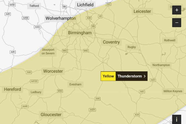
A Met Office thunderstorm warning is in place for parts of the West Midlands today (Saturday 29 August).
The yellow thunderstorm warning will be in place for Birmingham, Worcester and Hereford until 9pm.


The warning - which has a medium likelihood and a low impact - reads: “While most places will miss the worst, heavy thundery showers may bring some impacts this afternoon and evening.
“There is a good chance driving conditions will be affected by spray, standing water and/or hail, leading to longer journey times by car and bus. Some flooding of a few homes and businesses likely, leading to some damage to buildings or structures. Probably some damage to a few buildings and structures from lightning strikes. Delays to train services are possible. Some short-term loss of power and other services is likely.
“An area of heavy showers and thunderstorms will move across this region during the afternoon and early evening, affecting areas in the west first and moving progressively east towards evening with drier weather following. Some places could see 15-25 mm of rain in an hour, and 30 mm in two to three hours, with hail and lightning additional hazards.”
Met Office West Midlands weather forecast
Saturday day (29 August)
A bright start in the east but soon turning cloudy from the west with outbreaks of rain arriving from early morning, these heavy and perhaps thundery. Turning brighter later, squally rain is likely to across the south of the region. Maximum temperature 21 °C.
Saturday night (29 August)
Squally rain and showers will continue to clear to the east this evening, with most areas becoming dry overnight with clear spells developing. Minimum temperature 14 °C.
Sunday (30 August)
A cloudy start on Sunday with sunny spells soon giving way to showers, these will prove heavy with thunder and hail during the afternoon and evening. Temperatures close to normal. Maximum temperature 20 °C.
Outlook for Monday (31 August) to Wednesday (2 September)
Unsettled throughout with showers, these locally heavy and thundery. Staying warm to start with but turning fresher as winds shift to a westerly and strengthen from Monday.