Discover the West Midlands in times gone by at your fingertips

This article contains affiliate links. We may earn a small commission on items purchased through this article, but that does not affect our editorial judgement.
and live on Freeview channel 276
From devastating bomb damage during the blitz to an iconic emblem of the industrial revolution in years gone by.
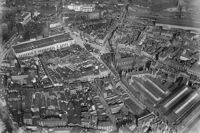
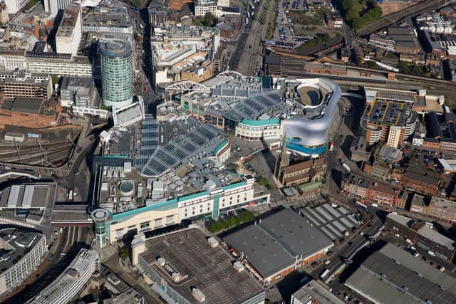
These are just some of the fascinating images now available on Historic England’s new Aerial Photo Explorer which allows users to search and explore times gone by from the sky at the click of a button.
Advertisement
Hide AdAdvertisement
Hide AdThe online portal allows you to search via postcode, so you can check out what photos are available where you live - or maybe you would like to see what Villa Park, St Andrews or The Hawthorns looked like back in the day.
There are over 400,000 aerial photos of England to explore - so there you may not be able to pinpoint every spot of the region you would like.
But there are so many fascinating options to discover in the West Midlands showing the region’s urban and rural landscapes over the last 100 years.

These include:
- Devasting bomb damage: a range ofpost-war views of Coventry taken in the 1940s show the effects of the blitz and are a timely reminder that bomb damage was a feature of many British towns and cities long after the Second World War had ended. Ruined Coventry Cathedral is centre stage in the photo. A later aerial image from 2017 shows how the city eventually healed and developed despite experiencing wide-scale destruction.
- Iconic emblem of the industrial revolution: an image of Ironbridge, Coalbrookdale in Shropshire, shows the Ironbridge Gorge World Heritage Site in 1934. The mineral-rich gorge was the site of technological innovation including smelting iron with coke. The famous bridge was the first in the world to be made out of cast iron and strong enough to carry industrial goods being produced in the area.
- From monks to mills: an image of Powick Bridge and Powick Mills in Worcester is backdrop to England’s religious and industrial past. The original bridge was constructed before 1447 by monks from Malvern Priory. Two centuries later, it was the scene of the ‘Battle of Powick Bridge’ during the first English Civil War. The two arches over the brook were broken down in 1651 as part of Worcester’s defences during the Battle of Worcester and rebuilt during the 17th century.
How much of England does the Aerial Photo Explorer cover?
Over 400,000 images from 1919 to the present day have been added to the tool, covering nearly 30% (c.15,000 square miles) of England, allowing people immediate digital access to Historic England’s nationally important collection of aerial photographs.
Advertisement
Hide AdAdvertisement
Hide AdAround 300,000 of these are the work of Historic England’s Aerial Investigation and Mapping team. Established in 1967, the team takes photographs of England from the air to discover new archaeological sites, create archaeological maps and monitor the condition of historic sites across the country.
The remaining 100,000 images come from the Historic England Archive aerial photography collection, which numbers over two million images in total, and includes important historic photography, including interwar and post-war images from Aerofilms Ltd and The Royal Air Force.
By opening up these images to the public through this accessible online tool, Historic England hopes that people will use it to research their local areas, offering an insight into a century of changes and development. This will allow them potentially to make their own discoveries about their local areas. It will also provide industry professionals and local authorities with a useful resource to help planning, heritage projects and archaeological investigation.
What has Historic England said about the Aerial Photographer Explorer tool?
Louise Brennan, Midlands Regional Director, Historic England said: “There is a wealth of fascinating images waiting to be discovered through our new Aerial Photographer Explorer tool. It has been designed to give free, instant access to the sort of photography our team uses every day to map England’s historic past. We hope it will inspire people to delve a little deeper into stories about their local area as well as reminding them how the passing of time and human activity has shaped our built and natural heritage.”
Advertisement
Hide AdAdvertisement
Hide AdNigel Huddleston MP, Minister for Heritage said: "What better way to discover our shared history than through this fascinating new online tool which offers a bird’s eye view of our past. I can’t wait to discover more about my local area and encourage everyone to explore the thousands of English sites from the last century."
Over the coming years, Historic England aims to expand the platform, as more of the six million aerial images in Historic England Archive are digitised.
To search the platform, visit: Historic England Aerial Photos
A message from the editor:
Thank you for reading. BirminghamWorld is Birmingham’s latest news website, championing everything that is great about our city - reporting on news, lifestyle and sport. We want to start a community among our readers, so please follow us on Facebook, Twitter and Instagram and keep the conversation going.
Comment Guidelines
National World encourages reader discussion on our stories. User feedback, insights and back-and-forth exchanges add a rich layer of context to reporting. Please review our Community Guidelines before commenting.