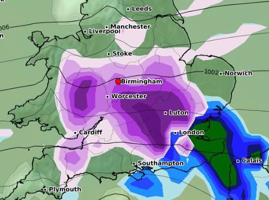
'Double UK snow wall' - full Birmingham Met Office forecast with fears new 'Beast from the East' due
and live on Freeview channel 276
A phenomenon referred to as a 'double snow wall' is expected to sweep across parts of the UK in February as the Met Office predicts increased chance of wintry weather during the period.
According to reports, a significant drop in temperatures is expected on February 5, accompanied by the possibility of additional snowfall on February 6. Regions including Greater Manchester, as well as sections of West Yorkshire and North Yorkshire, are expected to experience flurries and snow showers on February 5, resulting in an accumulation of up to 2cm of snow.
Advertisement
Hide AdAdvertisement
Hide AdExacta Weather forecaster James Madden also told the Daily Star that there could be a 'myriad of snow events' in February. He said a stratospheric warming (SSW) which would see a change in wind patterns high up in the atmosphere has been 'confirmed'. This process lead to the bitterly cold Beast from the East in 2018 in which heavy snowfall hit the UK.
The Met Office's long-range forecast says there is a chance of colder conditions between February 3 and 12, but will Birmingham and the West Midlands be affected?
Birmingham weather forecast
As it stands, the Met Office hasn't forecast any snow for the region just yet, but the weather forecast provider has said that there is an 'increased chance of wintry weather, especially northern and central UK' between February 3 and 12.
And WX Charts, which are compiled from Met Desk data, show Birmingham and Worcestershire potentially being hit with snow on February 6. The maps show some areas of Birmingham turning purple on February 6, an indication of snow. The map is colour coded, with purple indicating snow, and the darker the colour, the more severe the snow is expected to be.
Advertisement
Hide AdAdvertisement
Hide AdSnow is also forecast on Monday, February 12, with the maps showing snow could hit the region.


Weather expert Nick Finnis wrote on Netweather: "So, are there any signs of colder weather returning in February? There are hints from recent teleconnection and longer-range model output for a pattern change towards mid-February that could introduce colder and more wintry weather."
He added: "When colder conditions will arrive and where they will come from is too early to say for now, but perhaps sometime through the second week of February, though perhaps not until mid-month. Despite the recent mild weather, there’s plenty of time for winter to bite back, even in March or April, though after February, any snow that settles tends not to hang around unless the air mass is unusually cold."
Birmingham Met Office forecast
Outlook for Thursday to Saturday:
Often bright on Thursday with sunny spells, then cloudier on Friday and Saturday with the odd showery outbreak possible, mostly over the hills. Becoming very mild but windy at times.
February 3 - February 12 (long range)
Advertisement
Hide AdAdvertisement
Hide AdThere is a chance colder conditions could then become established more widely during the first full week of February, with increased chance of wintry weather, especially northern and central UK, should Atlantic cloud and rain be forced to track across the south of the country. Equally, similar conditions to the start of the period could well prevail; confidence is low at this range in the weather type which will become most dominant.
Comment Guidelines
National World encourages reader discussion on our stories. User feedback, insights and back-and-forth exchanges add a rich layer of context to reporting. Please review our Community Guidelines before commenting.
